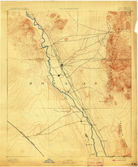
1893 Map of Las Cruces
USGS Topo · Published 1908About this map
Las Cruces and the neighboring community of Mesilla serve as the primary hubs of activity in this late 19th-century study of the Mesilla Valley. The landscape is defined by the vital waters of the Rio Grande, which supports a string of agricultural settlements including Dona Ana, San Miguel, and Chamberino. The arrival of the Atchison Topeka and Santa Fe Railroad parallel to the river indicates the shift from old wagon trails to a modern industrial corridor. To the east, the vertical rise of the Organ Mountains and San Augustin Peak hosts mining outposts like Organ City, while the northern reaches are guarded by the remains of Fort Selden. This survey captures the region before extensive modern irrigation changed the valley floor, showing the original placement of rail stops like Earlham and Mesquite along the basin's eastern edge.
Find a feature on this map
29 named features on this map. Tap any name to fly to it.
Don’t see what you’re looking for? This feature index may not catch every label — zoom into the map to look around manually.
Map Details
Editions of this 1893 Las Cruces Map
4 editions found
Other maps of this area

1891 · Las Cruces
USGS Topo · 1:125,000

1893 · Las Cruces
USGS Topo · 1:125,000

1896 · El Paso
USGS Topo · 1:125,000

1908 · El Paso
USGS Topo · 1:125,000

1916 · Tonuco
USGS Topo · 1:125,000

1916 · Point Of Sands
USGS Topo · 1:125,000

1917 · Canutillo
USGS Topo · 1:62,500

1917 · Noria
USGS Topo · 1:62,500

1917 · Mt. Riley
USGS Topo · 1:62,500

1918 · Mt. Riley
USGS Topo · 1:62,500