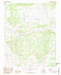
1983 Map of Las Nutrias
USGS Topo · Published 1983About this map
Tierra Amarilla Grant Boundary lines define much of this Northern New Mexico landscape, marking the historic land grant divisions that still shaped property and movement in the early 1980s. The settlement of Las Nutrias serves as a focal point along the Rio Nutrias, while the smaller namesake Nutrias sits to the west. This territory is characterized by a series of long, narrow drainages known as cañadas, including Cañada del Policarpo and Cañada del Humo, which indicate how water and geography dictated the layout of local ranching and travel routes. In the southeast corner, the flow of the Rio Cebolla meets the drainage of Cañada de la Lagunita near a designated Roadside Park, illustrating the mix of traditional land use and modern transit infrastructure in Rio Arriba County.
Find a feature on this map
12 named features on this map. Tap any name to fly to it.
Don’t see what you’re looking for? This feature index may not catch every label — zoom into the map to look around manually.
Map Details
Editions of this 1983 Las Nutrias Map
This is the sole edition of this map. No revisions or reprints were ever made.
Other maps of this area

1909 · Gallina
USGS Topo · 1:125,000

1918 · Abiquiu
USGS Topo · 1:125,000

1918 · Tusas
USGS Topo · 1:125,000

1953 · Alire
USGS Topo · 1:24,000

1953 · Canjilon
USGS Topo · 1:24,000

1953 · Navajo Peak
USGS Topo · 1:24,000

1954 · Aztec
USGS Topo · 1:250,000

1955 · Cebolla
USGS Topo · 1:62,500

1955 · Tierra Amarilla
USGS Topo · 1:62,500

1958 · Aztec
USGS Topo · 1:250,000