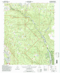
1995 Map of Las Tablas
USGS Topo · Published 1997About this map
Carson National Forest terrain dominates this New Mexico landscape, centered on the management areas of the Vallecitos Sustained Yield Unit. The map details a high-elevation environment defined by water management and resource extraction, featuring numerous livestock tanks like Posos Tank and Hondito Tank alongside historic mining sites such as the Lonesome Mine and Apaches No 2 Mine. The high point of Kiowa Mountain Lookout provides a vantage over the drainage of the Rio Tusas and the El Rito Tres Piedras.
Find a feature on this map
47 named features on this map. Tap any name to fly to it.
Don’t see what you’re looking for? This feature index may not catch every label — zoom into the map to look around manually.
Map Details
Editions of this 1995 Las Tablas Map
This is the sole edition of this map. No revisions or reprints were ever made.
Other maps of this area

1918 · Abiquiu
USGS Topo · 1:125,000

1918 · Tusas
USGS Topo · 1:125,000

1953 · Valle Grande Peak
USGS Topo · 1:24,000

1953 · La Madera
USGS Topo · 1:24,000

1954 · Raton
USGS Topo · 1:250,000

1954 · Aztec
USGS Topo · 1:250,000

1958 · Raton
USGS Topo · 1:250,000

1958 · Aztec
USGS Topo · 1:250,000

1961 · Servilleta Plaza
USGS Topo · 1:24,000

1962 · Aztec
USGS Topo · 1:250,000