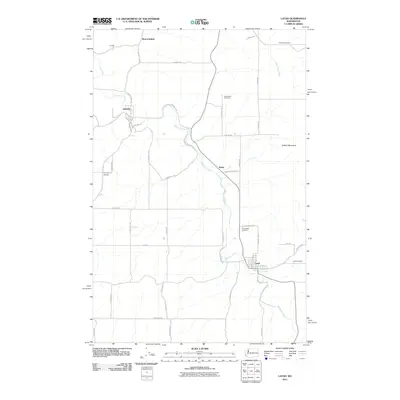
2011 Map of Latah
USGS Topo · Published 2011About this map
Hangman Creek meanders through the heart of this Spokane County landscape, serving as the primary drainage for a region defined by agricultural plots and scattered settlements. Near the creek's southern bends, the town of Latah is organized around a grid of streets including N Main St and E Market St, located just north of Cove Creek. The mapping reveals a distinct pattern of rural life, with family-named roads and multiple burial sites such as Latah Cemetery and Farmington Cemetery serving the surrounding community.
Find a feature on this map
46 named features on this map. Tap any name to fly to it.
Don’t see what you’re looking for? This feature index may not catch every label — zoom into the map to look around manually.
Map Details
Editions of this 2011 Latah Map
This is the sole edition of this map. No revisions or reprints were ever made.
Other maps of this area

1903 · Oakesdale
USGS Topo · 1:125,000

1905 · Oakesdale
USGS Topo · 1:125,000

1954 · Spangle
USGS Topo · 1:62,500

1954 · Fairfield
USGS Topo · 1:62,500

1955 · Spokane
USGS Topo · 1:250,000

1958 · Spokane
USGS Topo · 1:250,000

1964 · Oakesdale
USGS Topo · 1:24,000

1964 · Tekoa
USGS Topo · 1:24,000
1964 · Rosalia
USGS Topo · 1:24,000
1980 · Fairfield
USGS Topo · 1:24,000