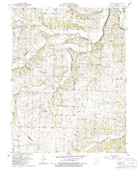
1951 Map of Latham
USGS Topo · Published 1986About this map
Latham serves as the central hub for this Missouri landscape, which is defined by the branching waterways of the Moreau Creek system. The map documents a rural society deeply rooted in its local institutions, evidenced by a dense distribution of country schools and churches. Prominent landmarks such as the Moreau Ch and Moreau Cem to the north, and Bethel Ch to the south, indicate long-established community centers. The drainage patterns of Smith Creek, Dry Fork, and North Fork Moreau Creek dictate the terrain's layout, where ridges are occupied by family-named schools like Oak Dale Sch and Hazel Dell Sch. This 1951 survey, with later revisions, captures the area during a period when the rural school district system remained a visible part of the Moniteau and Morgan County borderlands, shortly before the widespread consolidation of small township districts.
Find a feature on this map
28 named features on this map. Tap any name to fly to it.
Don’t see what you’re looking for? This feature index may not catch every label — zoom into the map to look around manually.
Map Details
Editions of this 1951 Latham Map
2 editions found
Other maps of this area

1888 · Versailles
USGS Topo · 1:125,000

1888 · Boonville
USGS Topo · 1:125,000

1893 · Versailles
USGS Topo · 1:125,000

1904 · Eldon
USGS Topo · 1:62,500

1904 · Gravois Mills
USGS Topo · 1:62,500

1947 · Jefferson City
USGS Topo · 1:250,000

1949 · Gravois Mills
USGS Topo · 1:62,500

1951 · California South
USGS Topo · 1:24,000

1951 · Latham
USGS Topo · 1:24,000

1952 · Tipton
USGS Topo · 1:24,000