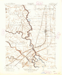
1915 Map of Lathrop
USGS Topo · Published 1947About this map
The confluence of the San Joaquin River and Old River dominates this 1912 survey of the California delta, where complex waterways and land grants define the local geography. Large tracts of land carry Spanish-influenced names such as El Pescadero (Grimes) and Campo de los Franceses, reflecting the era of Mexican land grants that predated American settlement. The town of Lathrop appears as a critical rail junction where the Southern Pacific (Fresno Line) and Western Pacific railroads intersect, highlighting the area's importance as a transportation hub for San Joaquin County.
Find a feature on this map
21 named features on this map. Tap any name to fly to it.
Don’t see what you’re looking for? This feature index may not catch every label — zoom into the map to look around manually.
Map Details
Editions of this 1915 Lathrop Map
2 editions found
Other maps of this area

1913 · Stockton
USGS Topo · 1:31,680

1913 · Holt
USGS Topo · 1:31,680

1914 · Burnham
USGS Topo · 1:31,680

1914 · Manteca
USGS Topo · 1:31,680

1914 · Union Island
USGS Topo · 1:31,680

1915 · Vernalis
USGS Topo · 1:31,680

1915 · Lathrop
USGS Topo · 1:31,680

1915 · Ripon
USGS Topo · 1:31,680

1916 · Tracy
USGS Topo · 1:31,680

1922 · Carbona
USGS Topo · 1:62,500