
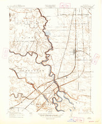
1915 Map of Lathrop
USGS Topo · Published 1915About this map
San Joaquin River meanders through a landscape defined by complex water management and overlapping land grants in the early twentieth century. The map highlights the agricultural and transport infrastructure of the San Joaquin Delta, notably within Roberts Island and the expansive tracts of El Pescadero and Campo de los Franceses. Local life centers around rural educational hubs like Island School, Mossdale School, and Rustic School, while the settlement of Lathrop serves as a critical railroad junction.
Find a feature on this map
22 named features on this map. Tap any name to fly to it.
Don’t see what you’re looking for? This feature index may not catch every label — zoom into the map to look around manually.
Map Details
Editions of this 1915 Lathrop Map
2 editions found
Other maps of this area

1913 · Stockton
USGS Topo · 1:31,680

1913 · Holt
USGS Topo · 1:31,680

1914 · Burnham
USGS Topo · 1:31,680

1914 · Manteca
USGS Topo · 1:31,680

1914 · Union Island
USGS Topo · 1:31,680

1915 · Vernalis
USGS Topo · 1:31,680

1915 · Ripon
USGS Topo · 1:31,680

1916 · Tracy
USGS Topo · 1:31,680

1922 · Carbona
USGS Topo · 1:62,500
1941 · Modesto West
USGS Topo · 1:62,500