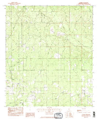
1982 Map of Latimer
USGS Topo · Published 1982About this map
Latimer is the central settlement in this coastal Mississippi landscape, situated where the lowlands meet the dense timber of the De Soto National Forest and the Red Creek State Wildlife Management Area. The 1980s terrain is defined by a dense network of winding bayous and creeks, including Costapia Bayou and Bluff Creek, which drain the forested hills into the Gulf watershed. Cultural features are concentrated along routes like the Daisy-Vestry Road and Seaman Road, reflecting a rural community deeply tied to its land through forestry and small-scale agriculture. The presence of the University of Mississippi Forest highlights the regional importance of research and timber management during this era. Local history is anchored by numerous small family and community sites, such as the Seymour Cem and Bethel Hill Ch, while a prominent Lookout Tower stands as a sentinel over the vast pine stands.
Find a feature on this map
36 named features on this map. Tap any name to fly to it.
Don’t see what you’re looking for? This feature index may not catch every label — zoom into the map to look around manually.
Map Details
Editions of this 1982 Latimer Map
2 editions found
Other maps of this area

1941 · Vancleave
USGS Topo · 1:62,500

1943 · Pascagoula
USGS Topo · 1:62,500

1943 · Vancleave
USGS Topo · 1:62,500

1944 · Vancleave
USGS Topo · 1:62,500

1953 · Mobile
USGS Topo · 1:250,000

1954 · Vestry
USGS Topo · 1:62,500

1954 · Ocean Springs
USGS Topo · 1:24,000

1954 · Biloxi
USGS Topo · 1:24,000

1954 · Biloxi
USGS Topo · 1:62,500

1955 · Pascagoula
USGS Topo · 1:62,500