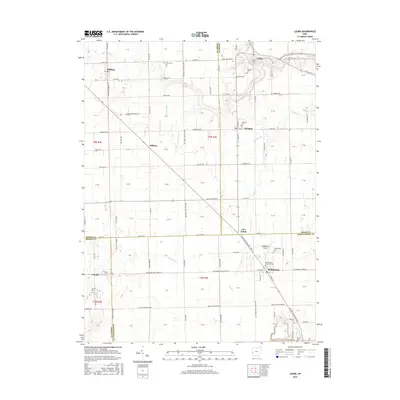
2016 Map of Laura
USGS Topo · Published 2016About this map
The village of Phillipsburg and the surrounding agricultural lands of Montgomery, Miami, Darke, and Preble counties define this modern survey. The landscape is marked by a network of small drainage features such as Baker Ditch and Shank Ditch, which support the intensive farming traditional to this part of Ohio. Genealogical interest is high throughout the quadrangle, with numerous small burial grounds including Mote Cem, Potsdam Cem, and the Swank Cem near the southern boundary. Transport is anchored by the Phillipsburg Airport and a grid of rural roads like Gettysburg-Pittsburg Rd, connecting established settlements like Pittsburg, Laura, and Potsdam. The map traces the headwaters of Brush Cr and the N Br Wolf Cr, illustrating how the natural topography of the Miami Valley continues to shape local settlement patterns.
Find a feature on this map
129 named features on this map. Tap any name to fly to it.
Don’t see what you’re looking for? This feature index may not catch every label — zoom into the map to look around manually.
Map Details
Editions of this 2016 Laura Map
This is the sole edition of this map. No revisions or reprints were ever made.
Other maps of this area

1905 · Brookville
USGS Topo · 1:62,500

1911 · Covington
USGS Topo · 1:62,500

1944 · Covington
USGS Topo · 1:62,500

1953 · Cincinnati
USGS Topo · 1:250,000

1953 · Muncie
USGS Topo · 1:250,000

1955 · West Milton
USGS Topo · 1:24,000
1955 · Trotwood
USGS Topo · 1:24,000

1956 · Muncie
USGS Topo · 1:250,000

1957 · Cincinnati
USGS Topo · 1:250,000

1961 · Laura
USGS Topo · 1:24,000