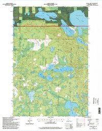
1996 Map of Laura Lake
USGS Topo · Published 1998About this map
Glacial lakes and thick timber dominate this portion of Cass County, where the Chippewa National Forest and Land O' Lakes State Forest converge. The landscape is defined by an intricate network of waterways, including the large expanse of Laura Lake near the township of Remer. The hydrography, compiled by the Minnesota Department of Conservation, reveals the complex drainage patterns of the region, from the connected Upper Trelipe Lake and Lower Trelipe Lake to the scattered smaller basins like Mitten Lake and Lake Twenty-six. This survey reflects the mid-1990s character of the Northwoods, showing a region managed for conservation and recreation. Notable landmarks for local history include several Gravel Pits and the Thunder Lake State Forest Boundary, marking the transition between different state and federal land management areas during this era.
Find a feature on this map
22 named features on this map. Tap any name to fly to it.
Don’t see what you’re looking for? This feature index may not catch every label — zoom into the map to look around manually.
Map Details
Editions of this 1996 Laura Lake Map
This is the sole edition of this map. No revisions or reprints were ever made.
Other maps of this area

1953 · Duluth
USGS Topo · 1:250,000

1953 · Brainerd
USGS Topo · 1:250,000

1954 · Bemidji
USGS Topo · 1:250,000

1954 · Hibbing
USGS Topo · 1:250,000

1957 · Brainerd
USGS Topo · 1:250,000

1957 · Bemidji
USGS Topo · 1:250,000

1957 · Hibbing
USGS Topo · 1:250,000

1958 · Bemidji
USGS Topo · 1:250,000

1958 · Hibbing
USGS Topo · 1:250,000

1958 · Brainerd
USGS Topo · 1:250,000