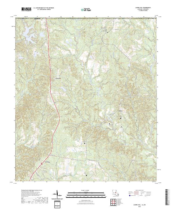
2024 Map of Laurel Hill
USGS Topo · Published 2024About this map
West Fork Thompson Creek and its many tributaries, including Sand Branch and Dry Creek, carve through the rolling terrain of West Feliciana Parish in this recent survey. The landscape is defined by its deep genealogical roots, visible in the high density of family and community burial grounds such as McCausland Cem, Richardson Cem, and Walker Cem. Settlements like Laurel Hill, Spillman, and Alice are situated along a network of parish roads and routes like Spillman Rd and Harris Corner Rd. The map illustrates a rural settlement pattern where life centers around historic congregations and family landmarks, evidenced by the Beech Grove Baptist Church Cem near the northern boundary. Modern infrastructure, including Fire Tower Rd, provides a framework for managing the wooded creek valleys that dominate the local topography.
Find a feature on this map
69 named features on this map. Tap any name to fly to it.
Don’t see what you’re looking for? This feature index may not catch every label — zoom into the map to look around manually.
Map Details
Editions of this 2024 Laurel Hill Map
This is the sole edition of this map. No revisions or reprints were ever made.
Other maps of this area

1906 · Bayou Sara
USGS Topo · 1:125,000

1936 · Woodville
USGS Topo · 1:62,500

1939 · St. Francisville
USGS Topo · 1:62,500

1941 · Lost Creek
USGS Topo · 1:31,680

1945 · Jackson
USGS Topo · 1:31,680

1945 · Lost Creek
USGS Topo · 1:31,680

1953 · Natchez
USGS Topo · 1:250,000

1954 · Elm Park
USGS Topo · 1:24,000
1954 · Jackson
USGS Topo · 1:24,000

1954 · Baton Rouge
USGS Topo · 1:250,000