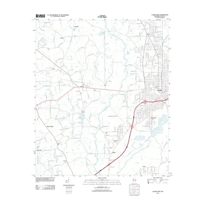
2012 Map of Laurel West
USGS Topo · Published 2012About this map
Laurel serves as the eastern anchor for this landscape, where the urban grid gives way to the scattered settlements and timbered creek bottoms of Jones County. The western outskirts are characterized by a network of rural communities including Calhoun, Springhill, and Pleasant Ridge. Aviation history is prominent at Hesler-Noble Field Airport, which occupies a large central tract between the city and the outlying Indian Springs Lake. This area is particularly dense with burial grounds that map the lineage of local families, from the Spring Hill Cem in the north to Currie Cem in the south. The terrain is defined by the drainage of Tallahoma Cr and its numerous tributaries like Mill Cr and Spring Cr, which have shaped the placement of early homesteads and roads. To the southwest, the elevation rises toward Buffalo Hill, overlooking the rural crossroads of Mount Zion.
Find a feature on this map
124 named features on this map. Tap any name to fly to it.
Don’t see what you’re looking for? This feature index may not catch every label — zoom into the map to look around manually.
Map Details
Editions of this 2012 Laurel West Map
This is the sole edition of this map. No revisions or reprints were ever made.
Other maps of this area

1953 · Hattiesburg
USGS Topo · 1:250,000

1958 · Hattiesburg
USGS Topo · 1:250,000

1964 · Moss
USGS Topo · 1:24,000

1964 · Sandersville
USGS Topo · 1:24,000

1964 · Laurel East
USGS Topo · 1:24,000

1964 · Laurel West
USGS Topo · 1:24,000

1964 · Ellisville
USGS Topo · 1:24,000

1964 · Lanham
USGS Topo · 1:24,000

1965 · Hebron
USGS Topo · 1:24,000

1965 · Moselle
USGS Topo · 1:24,000