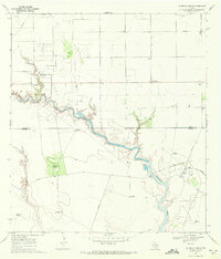
1969 Map of Laureles Ranch
USGS Topo · Published 1972About this map
Petronila Creek and Chiltipin Creek carve through this coastal prairie landscape at the intersection of Nueces and Kleberg counties. The 1969 landscape is defined by the extensive petroleum infrastructure of the Luby Field, where numerous oil wells and the Stanolind-Luby Camp Refinery signal the region's industrial focus. Sparse ranching outposts such as Laureles Ranch and Santa Cruz Ranch represent the traditional land use, connected by a network of private roads and naming-conventions that reflect local heritage.
Find a feature on this map
24 named features on this map. Tap any name to fly to it.
Don’t see what you’re looking for? This feature index may not catch every label — zoom into the map to look around manually.
Map Details
Editions of this 1969 Laureles Ranch Map
2 editions found
Other maps of this area

1924 · Petronilla
USGS Topo · 1:62,500

1925 · Oso Creek
USGS Topo · 1:62,500

1928 · Sarita
USGS Topo · 1:125,000

1950 · Corpus Christi
USGS Topo · 1:250,000

1951 · South Bird Island NW
USGS Topo · 1:24,000

1951 · Oso Creek NW
USGS Topo · 1:24,000

1951 · Riviera Beach NE
USGS Topo · 1:24,000

1951 · Oso Creek
USGS Topo · 1:62,500

1951 · South Bird Island
USGS Topo · 1:62,500

1952 · Riviera Beach NW
USGS Topo · 1:24,000