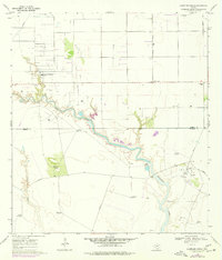
1969 Map of Laureles Ranch
USGS Topo · Published 1977About this map
Petronila Creek meanders across the South Texas coastal plain, defining the landscape of this rural ranching and energy corridor during the late 1960s. The map captures the industrial infrastructure of the Luby Oil Field, where a refinery, multiple oil wells, and the Stanolind-Luby Camp highlight the region's mid-century petroleum development. This activity contrasts with the traditional sprawling landholdings of the Laureles Ranch and Santa Cruz Ranch.
Find a feature on this map
26 named features on this map. Tap any name to fly to it.
Don’t see what you’re looking for? This feature index may not catch every label — zoom into the map to look around manually.
Map Details
Editions of this 1969 Laureles Ranch Map
2 editions found
Other maps of this area

1924 · Petronilla
USGS Topo · 1:62,500

1925 · Oso Creek
USGS Topo · 1:62,500

1928 · Sarita
USGS Topo · 1:125,000

1950 · Corpus Christi
USGS Topo · 1:250,000

1951 · South Bird Island NW
USGS Topo · 1:24,000

1951 · Oso Creek NW
USGS Topo · 1:24,000

1951 · Riviera Beach NE
USGS Topo · 1:24,000

1951 · Oso Creek
USGS Topo · 1:62,500

1951 · South Bird Island
USGS Topo · 1:62,500

1952 · Riviera Beach NW
USGS Topo · 1:24,000