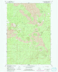
1963 Map of Lava Cast Forest
USGS Topo · Published 1981About this map
The Deschutes National Forest encompasses a landscape defined by volcanic activity and the transition between high desert and mountain ecosystems. This 1963 survey, updated through 1979, centers on the unique geologic formations of the Lava Cast Forest Road area. The presence of a Cinder Pit and multiple cinder cones like Mokst Butte and Sugar Pine Butte indicates the heavy volcanic influence that shaped this terrain. The map provides a detailed look at the infrastructure of the Lava Cast Forest Campground and the access routes across the Lava flows, which are significant for understanding the recreational and geological management of central Oregon during the mid-to-late 20th century. To the south, the terrain rises into the Paulina Mountains, where higher elevations like Kawak Butte overlook the vast lava fields below.
Find a feature on this map
13 named features on this map. Tap any name to fly to it.
Don’t see what you’re looking for? This feature index may not catch every label — zoom into the map to look around manually.
Map Details
Editions of this 1963 Lava Cast Forest Map
3 editions found
Other maps of this area

1931 · Newberry Crater
USGS Topo · 1:125,000

1935 · Newberry Crater
USGS Topo · 1:125,000

1955 · Crescent
USGS Topo · 1:250,000

1957 · Crescent
USGS Topo · 1:250,000

1958 · Crescent
USGS Topo · 1:250,000
1963 · Lava Cast Forest
USGS Topo · 1:24,000
1963 · Lava Butte
USGS Topo · 1:24,000
1963 · Benham Falls
USGS Topo · 1:24,000
1963 · Anns Butte
USGS Topo · 1:24,000
1963 · Finley Butte
USGS Topo · 1:24,000