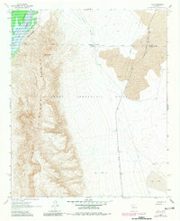
1961 Map of Lava
USGS Topo · Published 1981About this map
The Fra Cristobal Range dominates this portion of Sierra County, rising sharply from the eastern banks of the Rio Grande. In the northwest, the Elephant Butte Reservoir and its Conveyance Channel highlight the region's essential water management infrastructure. To the east, the terrain opens into a broad basin marked by the Atchison Topeka and Santa Fe railroad line, which parallels a major Pipeline through the desert flats. Small pockets of human activity are scattered across this arid landscape, including the settlement of Silver near Silver Canyon and the Lava Well Ranch located at an Indefinite Boundary. The map also details the extensive Pedro Armendaris No 33 land grant, showing how private ranching interests and early transit routes shaped the development of this volcanic and mountainous territory.
Find a feature on this map
24 named features on this map. Tap any name to fly to it.
Don’t see what you’re looking for? This feature index may not catch every label — zoom into the map to look around manually.
Map Details
Editions of this 1961 Lava Map
Other maps of this area

1916 · Salinas Peak
USGS Topo · 1:125,000

1948 · Val Verde
USGS Topo · 1:62,500

1948 · Malpais Well
USGS Topo · 1:62,500

1954 · Tularosa
USGS Topo · 1:250,000

1958 · Tularosa
USGS Topo · 1:250,000

1961 · Paraje Well
USGS Topo · 1:24,000

1961 · Black Bluffs
USGS Topo · 1:24,000

1961 · Black Hill
USGS Topo · 1:24,000

1961 · Crocker
USGS Topo · 1:24,000

1961 · Lava
USGS Topo · 1:24,000