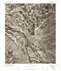
1971 Map of Laveen
USGS Topo · Published 1972About this map
Gila River meanders through the landscape of Maricopa and Pinal counties, carving a broad, textured channel across the southwestern desert. This 1971 orthophotomosaic, created from aerial photography, provides a literal visual record of the era's agricultural patterns and natural terrain. The grid-like fields of the Laveen community stand in sharp contrast to the braided riverbed and the brush-covered slopes of the nearby mountains. To the southeast, the settlement of Komatke appears as a small cluster of structures and roads bordering the river, illustrating the historical reliance on water sources for habitation in this arid region. The high-contrast imagery highlights the transition between irrigated farm plots and the undisturbed desert wash, capturing a moment of development just south of the Phoenix metropolitan area.
Find a feature on this map
3 named features on this map. Tap any name to fly to it.
Don’t see what you’re looking for? This feature index may not catch every label — zoom into the map to look around manually.
Map Details
Editions of this 1971 Laveen Map
This is the sole edition of this map. No revisions or reprints were ever made.
Other maps of this area

1912 · Phoenix
USGS Topo · 1:62,500

1913 · Maricopa
USGS Topo · 1:62,500

1914 · Phoenix
USGS Topo · 1:62,500

1915 · Maricopa
USGS Topo · 1:62,500

1946 · Avondale
USGS Topo · 1:62,500

1948 · Cashion
USGS Topo · 1:62,500

1951 · Mobile
USGS Topo · 1:62,500

1952 · Lone Butte
USGS Topo · 1:24,000

1952 · Laveen
USGS Topo · 1:24,000
1952 · Pima Butte
USGS Topo · 1:24,000