
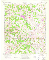
1956 Map of Laverty
USGS Topo · Published 1959About this map
Cement Gas Field dominates the central and southern portions of this Oklahoma landscape, where numerous oil wells are scattered across the terrain of North Hillsboro and South Chandler. This 1950s survey captures a transition in land use, showing the industrial footprint of petroleum extraction alongside established agricultural communities. The settlement of Laverty serves as a local hub, supported by the St Louis and San Francisco railroad and several country schools. Water resources are central to the area, including the Lake Louis Burtschi State Game Reservation and the winding course of the Little Washita River in the southeast corner. For genealogists, the map is particularly valuable for its documentation of local landmarks such as Pioneer Cemetery, Laverty Cemetery, and rural educational sites like Kechi School and Fairview School.
Find a feature on this map
25 named features on this map. Tap any name to fly to it.
Don’t see what you’re looking for? This feature index may not catch every label — zoom into the map to look around manually.
Map Details
Editions of this 1956 Laverty Map
2 editions found
Other maps of this area

1902 · Rush Springs
USGS Topo · 1:125,000

1904 · Chickasha
USGS Topo · 1:125,000

1945 · Anadarko
USGS Topo · 1:62,500

1949 · Cement
USGS Topo · 1:62,500

1949 · Rush Springs
USGS Topo · 1:62,500

1950 · Rush Springs
USGS Topo · 1:62,500

1954 · Oklahoma City
USGS Topo · 1:250,000

1955 · Lawton
USGS Topo · 1:250,000

1955 · Clinton
USGS Topo · 1:250,000

1956 · Fletcher
USGS Topo · 1:24,000