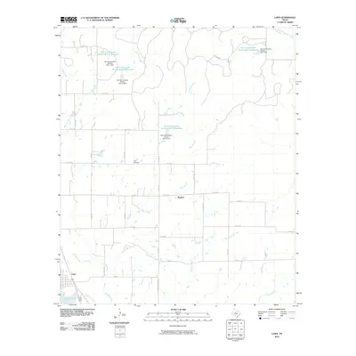
2010 Map of Lawn
USGS Topo · Published 2010About this map
Lawn and the settlement of Rogers anchor this West Texas landscape, where water management defines the rural infrastructure. The area is marked by an extensive network of drainage and conservation projects, including Santa Fe Lake and numerous Soil Conservation Service installations such as Soil Conservation Service Site 17 Reservoir and its associated Dam. These reservoirs are fed by a complex system of local waterways, including Jim Ned Creek, Twomile Creek, and Gray Branch, which illustrate the seasonal hydrology of Taylor County.
Find a feature on this map
46 named features on this map. Tap any name to fly to it.
Don’t see what you’re looking for? This feature index may not catch every label — zoom into the map to look around manually.
Map Details
Editions of this 2010 Lawn Map
This is the sole edition of this map. No revisions or reprints were ever made.
Other maps of this area

1890 · Abilene
USGS Topo · 1:125,000

1892 · Abilene
USGS Topo · 1:125,000

1954 · Abilene
USGS Topo · 1:250,000

1957 · Kirby Lake
USGS Topo · 1:62,500

1957 · Buffalo Gap
USGS Topo · 1:62,500

1958 · Abilene
USGS Topo · 1:250,000

1967 · Tuscola
USGS Topo · 1:24,000
1967 · McEwen Draw
USGS Topo · 1:24,000
1967 · Lawn
USGS Topo · 1:24,000
1967 · Oplin
USGS Topo · 1:24,000