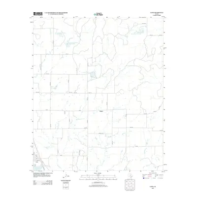
2012 Map of Lawn
USGS Topo · Published 2012About this map
Lawn and the nearby settlement of Rogers anchor this West Texas landscape, showing a region defined by agricultural water management and ranching infrastructure. The terrain is crisscrossed by several branches of the Jim Ned Cr system, including E Jim Ned Cr and Red Bank Cr. This era of the landscape is marked by numerous engineered water features, including the Soil Conservation Service Site 17 Reservoir and several other numbered sites designed for flood control and irrigation.
Find a feature on this map
50 named features on this map. Tap any name to fly to it.
Don’t see what you’re looking for? This feature index may not catch every label — zoom into the map to look around manually.
Map Details
Editions of this 2012 Lawn Map
This is the sole edition of this map. No revisions or reprints were ever made.
Other maps of this area

1890 · Abilene
USGS Topo · 1:125,000

1892 · Abilene
USGS Topo · 1:125,000

1954 · Abilene
USGS Topo · 1:250,000

1957 · Kirby Lake
USGS Topo · 1:62,500

1957 · Buffalo Gap
USGS Topo · 1:62,500

1958 · Abilene
USGS Topo · 1:250,000

1967 · Tuscola
USGS Topo · 1:24,000
1967 · McEwen Draw
USGS Topo · 1:24,000
1967 · Lawn
USGS Topo · 1:24,000
1967 · Oplin
USGS Topo · 1:24,000