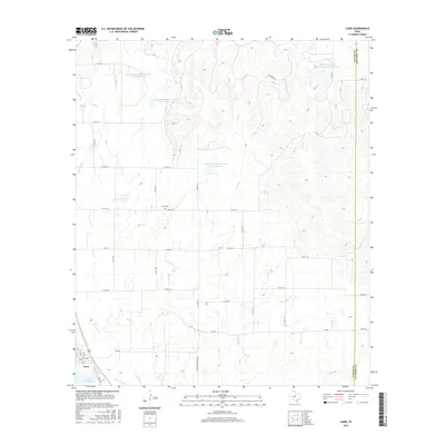
2016 Map of Lawn
USGS Topo · Published 2016About this map
The settlement of Lawn serves as the focal point in this portion of the Texas Big Country, situated near the southwestern corner of the Taylor and Callahan county line. The landscape is defined by a sophisticated water management network, featuring several man-made impoundments such as Soil Conservation Service Site 17 Reservoir, Soil Conservation Service Site 16 Reservoir, and Soil Conservation Service Site 15 Reservoir. These reservoirs supplement natural drainage systems like Jim Ned Cr and Twomile Cr, illustrating the region's historical reliance on water conservation for ranching and agriculture. Local family history is grounded at the Cope Cem, while the town itself is serviced by a Post Office and situated along the historic Abilene-Coleman Rd. Small bodies of water including Lake Lawn and Santa Fe Lake further characterize the immediate vicinity of the town site.
Find a feature on this map
48 named features on this map. Tap any name to fly to it.
Don’t see what you’re looking for? This feature index may not catch every label — zoom into the map to look around manually.
Map Details
Editions of this 2016 Lawn Map
This is the sole edition of this map. No revisions or reprints were ever made.
Other maps of this area

1890 · Abilene
USGS Topo · 1:125,000

1892 · Abilene
USGS Topo · 1:125,000

1954 · Abilene
USGS Topo · 1:250,000

1957 · Kirby Lake
USGS Topo · 1:62,500

1957 · Buffalo Gap
USGS Topo · 1:62,500

1958 · Abilene
USGS Topo · 1:250,000

1967 · Tuscola
USGS Topo · 1:24,000
1967 · McEwen Draw
USGS Topo · 1:24,000
1967 · Lawn
USGS Topo · 1:24,000
1967 · Oplin
USGS Topo · 1:24,000