1918 Map of Lawrence
USGS Topo · Published 1921About this map
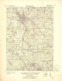
The Merrimac River anchors this detailed survey of northeastern Massachusetts, illustrating a landscape defined by industrial centers and an intricate web of rail lines just after the First World War. Lawrence sits at the heart of the region, flanked by the residential and academic character of Andover and North Andover. The map captures the significant presence of the Main Line of Boston and Maine Railroad alongside smaller spurs like the Lowell Br. of Boston & Maine R.R., which connected isolated manufacturing sites and institutions.
Find a feature on this map
160 named features on this map. Tap any name to fly to it.
Don’t see what you’re looking for? This feature index may not catch every label — zoom into the map to look around manually.
Map Details
Editions of this 1918 Lawrence Map
2 editions found

Other maps of this area

1886 · Lawrence
USGS Topo · 1:62,500

1886 · Lowell
USGS Topo · 1:62,500

1886 · Framingham
USGS Topo · 1:62,500

1888 · Newburyport
USGS Topo · 1:62,500

1888 · Haverhill
USGS Topo · 1:62,500

1888 · Lawrence
USGS Topo · 1:62,500

1888 · Salem
USGS Topo · 1:62,500

1889 · Framingham
USGS Topo · 1:62,500

1890 · Haverhill
USGS Topo · 1:62,500

1890 · Newburyport
USGS Topo · 1:62,500