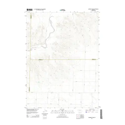
2014 Map of Lawrence Fork
USGS Topo · Published 2014About this map
Lawrence Fork meanders through this high-plains landscape, marking a prominent drainage system that cuts across the tri-county corner where Cheyenne, Morrill, and Banner counties meet. This 2014 survey illustrates a rural Nebraska environment defined by its systematic road grid and occasional water features. In the southwestern portion of the sheet, the Dvorak Reservoir provides a focused catchment area, while Rush Cr flows across the southeastern corner. The map traces the intersection of several significant local arteries, including Road 81 and Road 56, showing how the land is organized for agriculture and livestock. The terrain transitions from the relatively flat valley of the Lawrence Fork into more complex contours, reflecting the gradual elevation changes characteristic of the Nebraska Panhandle's western edge.
Find a feature on this map
17 named features on this map. Tap any name to fly to it.
Don’t see what you’re looking for? This feature index may not catch every label — zoom into the map to look around manually.
Map Details
Editions of this 2014 Lawrence Fork Map
This is the sole edition of this map. No revisions or reprints were ever made.
Other maps of this area

1898 · Camp Clarke
USGS Topo · 1:125,000

1954 · Scottsbluff
USGS Topo · 1:250,000

1958 · Scottsbluff
USGS Topo · 1:250,000

1972 · Mud Springs SW
USGS Topo · 1:24,000

1972 · Horsehead Ranch
USGS Topo · 1:24,000

1973 · Potter 2 SW
USGS Topo · 1:24,000

1973 · Bridgeport SW
USGS Topo · 1:24,000

1973 · Potter 2 SE
USGS Topo · 1:24,000

1973 · Potter 2 NW
USGS Topo · 1:24,000
1973 · Potter 2 NE
USGS Topo · 1:24,000