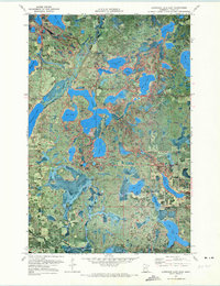
1971 Map of Lawrence Lake East
USGS Topo · Published 1973About this map
The Prairie River and its intricate network of connecting lakes dominate this 1971 orthophotomap of northern Minnesota. This particular study captures the landscape as a mosaic of dense vegetation and glacial waters, where the Balsam Lake Chapel and Balsam Lake Sch serve as the primary community markers in the northern sections. The map reveals the early industrial and transportation footprint of the region through numerous Gravel Pits and the Old Grade roadbed, which hints at former logging or rail paths cutting through the timber.
Find a feature on this map
33 named features on this map. Tap any name to fly to it.
Don’t see what you’re looking for? This feature index may not catch every label — zoom into the map to look around manually.
Map Details
Editions of this 1971 Lawrence Lake East Map
This is the sole edition of this map. No revisions or reprints were ever made.
Other maps of this area

1919 · Release
USGS Topo · 1:62,500

1920 · Trout Lake
USGS Topo · 1:62,500

1943 · Release
USGS Topo · 1:62,500

1952 · Nashwauk
USGS Topo · 1:24,000

1952 · Calumet
USGS Topo · 1:24,000

1952 · Pengilly
USGS Topo · 1:24,000

1952 · Bovey
USGS Topo · 1:24,000

1954 · Hibbing
USGS Topo · 1:250,000

1957 · Hibbing
USGS Topo · 1:250,000

1958 · Hibbing
USGS Topo · 1:250,000