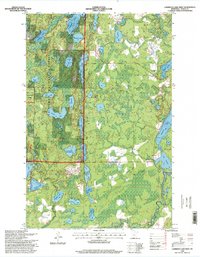
1996 Map of Lawrence Lake West
USGS Topo · Published 1998About this map
Chippewa National Forest defines the western portion of this landscape in Itasca County, where a complex network of glacial lakes and wetlands dictates the local geography. The map captures a moment in the mid-1990s when recreation and conservation efforts were well-established, visible in the extensive Skee-Di-Lakes Trail System and the Taconite Trail cutting through the northern woods. Water management and conservation are central to the area's character, evidenced by the Hanson Lake Impoundment and the protected Trout Lake Management Area. Near the southeastern shore of Lawrence Lake, the small Lawron Chapel stands as a focal point for the local community amidst the vast tracts of timber and water. The map's hydrography, from Wabana Lake to the chain including Middle Hanson Lake and Lower Hanson Lake, illustrates the intricate drainage patterns characteristic of this part of Minnesota.
Find a feature on this map
34 named features on this map. Tap any name to fly to it.
Don’t see what you’re looking for? This feature index may not catch every label — zoom into the map to look around manually.
Map Details
Editions of this 1996 Lawrence Lake West Map
This is the sole edition of this map. No revisions or reprints were ever made.
Other maps of this area

1919 · Release
USGS Topo · 1:62,500

1919 · Marcell
USGS Topo · 1:62,500

1920 · Trout Lake
USGS Topo · 1:62,500

1943 · Release
USGS Topo · 1:62,500

1952 · Calumet
USGS Topo · 1:24,000

1952 · Bovey
USGS Topo · 1:24,000

1953 · Cohasset East
USGS Topo · 1:24,000

1954 · Hibbing
USGS Topo · 1:250,000

1957 · Hibbing
USGS Topo · 1:250,000

1958 · Hibbing
USGS Topo · 1:250,000