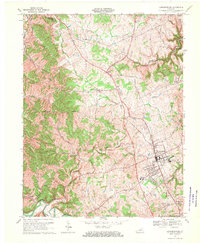
1967 Map of Lawrenceburg
USGS Topo · Published 1970About this map
The town of Lawrenceburg serves as the focal point of this late 1960s landscape, positioned near the intersection of the Southern Railway and local transit routes. The geography is defined by the winding course of the Salt River in the south and the drainage networks of Benson Creek and Little Benson Creek to the north, which carve through the central Kentucky hills. Cultural landmarks such as the Fairground, Water Tanks, and the County High Sch indicate the town's role as a regional hub.
Find a feature on this map
34 named features on this map. Tap any name to fly to it.
Don’t see what you’re looking for? This feature index may not catch every label — zoom into the map to look around manually.
Map Details
Editions of this 1967 Lawrenceburg Map
3 editions found
Other maps of this area

1905 · Harrodsburg
USGS Topo · 1:125,000

1922 · Frankfort
USGS Topo · 1:48,000

1923 · Waddy
USGS Topo · 1:48,000

1924 · Frankfort
USGS Topo · 1:62,500

1925 · Mount Eden
USGS Topo · 1:48,000

1927 · Mount Eden
USGS Topo · 1:62,500

1951 · Lawrenceburg
USGS Topo · 1:24,000

1952 · Ashbrook
USGS Topo · 1:24,000

1952 · Salvisa
USGS Topo · 1:24,000

1952 · Mc Brayer
USGS Topo · 1:24,000