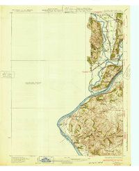
1932 Map of Lawrenceburg
USGS Topo · Published 1932About this map
The Ohio River curves sharply at the tri-state junction where Indiana, Kentucky, and Ohio meet, defining a landscape of river-bottom commerce and hillside settlements. This preliminary survey, based on data from 1915 and 1928, captures a pre-war era of river crossings and local education. Transit relies on traditional connections like the Lawrenceburg Ferry and Aurora Ferry, alongside the more permanent Suspension Bridge over the Whitewater River.
Find a feature on this map
44 named features on this map. Tap any name to fly to it.
Don’t see what you’re looking for? This feature index may not catch every label — zoom into the map to look around manually.
Map Details
Editions of this 1932 Lawrenceburg Map
3 editions found
Other maps of this area

1914 · West Cincinnati
USGS Topo · 1:62,500

1915 · Lawrenceburg
USGS Topo · 1:48,000

1915 · Harrison
USGS Topo · 1:48,000

1915 · Hamilton
USGS Topo · 1:62,500

1917 · Hamilton
USGS Topo · 1:62,500

1928 · Lawrenceburg
USGS Topo · 1:62,500

1932 · Lawrenceburg
USGS Topo · 1:62,500

1943 · Aberdeen
USGS Topo · 1:24,000

1943 · Aurora
USGS Topo · 1:24,000

1943 · Rising Sun
USGS Topo · 1:24,000