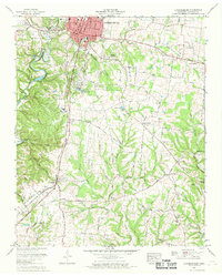
1966 Map of Lawrenceburg
USGS Topo · Published 1969About this map
Lawrenceburg serves as the focal point of this mid-1960s landscape, where the confluence of the Louisville and Nashville railroad and major thoroughfares like the Andrew Jackson Highway underscore its role as a regional crossroads. The town's infrastructure is well-defined, featuring the Courthouse, Post Office, and the sprawling grounds of the Lawrenceburg Golf and Country Club. Just west of the urban center, David Crockett State Park encompasses the New Shoal Creek Dam and its reservoir, reflecting the era’s investment in public recreation and water management.
Find a feature on this map
117 named features on this map. Tap any name to fly to it.
Don’t see what you’re looking for? This feature index may not catch every label — zoom into the map to look around manually.
Map Details
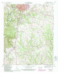
Editions of this 1966 Lawrenceburg Map
2 editions found
Other maps of this area

1936 · Deerfield
USGS Topo · 1:24,000

1936 · Campbellsville
USGS Topo · 1:24,000

1936 · Lawrenceburg
USGS Topo · 1:24,000

1936 · Ethridge
USGS Topo · 1:24,000

1936 · Long Branch
USGS Topo · 1:24,000

1936 · Loretto
USGS Topo · 1:24,000

1936 · Bodenham
USGS Topo · 1:24,000

1936 · Appleton
USGS Topo · 1:24,000

1936 · Bonnertown
USGS Topo · 1:24,000
1948 · Appleton
USGS Topo · 1:24,000