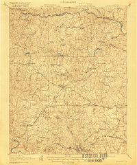
1921 Map of Lawrenceville
USGS Topo · Published 1921About this map
Lawrenceville serves as the focal point of this 1921 survey, situated within a landscape defined by the drainage basins of the Nottoway River to the north and the Meherrin River to the south. The area reflects a rural Virginia economy centered on tobacco and timber, as evidenced by the namesake settlement of Tobacco and numerous water-powered sites like Wheeler Mill and Masons Mill. A complex web of transit connections defines the county's development, with the Virginian, Seaboard Air Line, and Southern railroads intersecting near significant local centers such as Alberta and Dolphin.
Find a feature on this map
88 named features on this map. Tap any name to fly to it.
Don’t see what you’re looking for? This feature index may not catch every label — zoom into the map to look around manually.
Map Details
Editions of this 1921 Lawrenceville Map
2 editions found

Other maps of this area

1891 · Farmville
USGS Topo · 1:125,000

1893 · Farmville
USGS Topo · 1:125,000

1897 · Amelia
USGS Topo · 1:125,000

1918 · Lawrenceville
USGS Topo · 1:62,500

1919 · Mc Kenney
USGS Topo · 1:48,000

1919 · White Plains
USGS Topo · 1:48,000

1919 · Emporia
USGS Topo · 1:62,500

1920 · Lawrenceville
USGS Topo · 1:48,000

1920 · White Plains
USGS Topo · 1:62,500

1921 · Mc Kenney
USGS Topo · 1:62,500