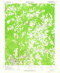
1963 Map of Lawrenceville
USGS Topo · Published 1964About this map
Lawrenceville serves as the focal point of this Brunswick County survey, showing the town's layout just as the mid-century era transitioned. The grounds of St Pauls College and St Pauls Ch dominate the northern portion of the town, while Oakwood Cem and Lawrenceville Cem mark the community's established history. This period finds the region heavily influenced by three distinct rail lines: the Seaboard Air Line passing through Alberta, the Norfolk and Western running through Dolphin, and the Norfolk and Danville serving Edgerton.
Find a feature on this map
49 named features on this map. Tap any name to fly to it.
Don’t see what you’re looking for? This feature index may not catch every label — zoom into the map to look around manually.
Map Details
Editions of this 1963 Lawrenceville Map
2 editions found
Other maps of this area

1918 · Lawrenceville
USGS Topo · 1:62,500

1919 · Mc Kenney
USGS Topo · 1:48,000

1919 · White Plains
USGS Topo · 1:48,000

1919 · Emporia
USGS Topo · 1:62,500

1920 · Lawrenceville
USGS Topo · 1:48,000

1920 · White Plains
USGS Topo · 1:62,500

1921 · Mc Kenney
USGS Topo · 1:62,500

1921 · Lawrenceville
USGS Topo · 1:62,500

1942 · Lawrenceville
USGS Topo · 1:62,500

1942 · Emporia
USGS Topo · 1:62,500