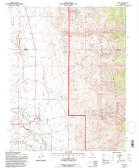
1994 Map of Laws
USGS Topo · Published 1997About this map
Laws and the surrounding Owens Valley landscape dominate this mid-1990s survey, highlighting the complex water management and mining history of the region. The map details an intricate network of irrigation and water transport, including the Mc Nally Canal, Rawson Canal, and the Laws Poleta Ditch, all situated near the meandering Owens River. These features reflect the long-standing agricultural and utility developments necessary to sustain life and industry in the shadow of the White Mountains.
Find a feature on this map
30 named features on this map. Tap any name to fly to it.
Don’t see what you’re looking for? This feature index may not catch every label — zoom into the map to look around manually.
Map Details
Editions of this 1994 Laws Map
This is the sole edition of this map. No revisions or reprints were ever made.
Other maps of this area

1913 · Bishop
USGS Topo · 1:125,000

1917 · White Mountain
USGS Topo · 1:125,000

1947 · Mariposa
USGS Topo · 1:250,000

1948 · Mariposa
USGS Topo · 1:250,000

1949 · Bishop
USGS Topo · 1:62,500

1951 · Bishop
USGS Topo · 1:62,500

1951 · Blanco Mountain
USGS Topo · 1:62,500

1957 · Mariposa
USGS Topo · 1:250,000

1962 · Mt. Barcroft
USGS Topo · 1:62,500

1962 · White Mtn. Peak
USGS Topo · 1:62,500