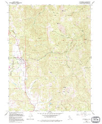
1967 Map of Laytonville
USGS Topo · Published 1994About this map
Long Valley serves as the central corridor for this Mendocino County landscape, where the town of Laytonville and the nearby Laytonville Rancheria are situated along the primary transit route. The survey highlights a mix of rural infrastructure and natural landmarks, including the Laytonville Cem and the small settlement of Cahto. Resource extraction and transport are evident through features like the Gravel Pit, a Quarry, and the Sloan Landing Strip.
Find a feature on this map
39 named features on this map. Tap any name to fly to it.
Don’t see what you’re looking for? This feature index may not catch every label — zoom into the map to look around manually.
Map Details
Editions of this 1967 Laytonville Map
3 editions found
Other maps of this area

1920 · Cummings
USGS Topo · 1:62,500

1920 · Covelo
USGS Topo · 1:62,500

1921 · Branscomb
USGS Topo · 1:62,500

1951 · Branscomb
USGS Topo · 1:62,500

1951 · Laytonville
USGS Topo · 1:62,500

1952 · Spyrock
USGS Topo · 1:62,500

1952 · Leggett
USGS Topo · 1:62,500

1957 · Ukiah
USGS Topo · 1:250,000

1960 · Ukiah
USGS Topo · 1:250,000
1966 · Longvale
USGS Topo · 1:24,000