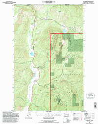
1992 Map of Leadpoint
USGS Topo · Published 1996About this map
Gladstone Mountain and Red Top Mountain anchor this survey of a densely mineralized corner of the Colville National Forest, just south of the international boundary. The settlement at Leadpoint serves as a central point for the surrounding topography, which is marked by an intensive history of extraction. Dozens of mining operations are documented, including the Gladstone Mine, the Electric Point Mine, and the Admiral Mine & Mill near Hartbauer Orchard. This industrial landscape is set against the rugged drainage basins of Deep Creek and Cedar Creek. The map identifies local landmarks such as the Cedar Creek Sch (Aban'd), preserving a record of earlier 20th-century rural infrastructure. High-altitude clearings like Hungate Clearing and various trails like the Terry Trail provide detail for those tracing historic land use and access in Stevens County.
Find a feature on this map
45 named features on this map. Tap any name to fly to it.
Don’t see what you’re looking for? This feature index may not catch every label — zoom into the map to look around manually.
Map Details
Editions of this 1992 Leadpoint Map
This is the sole edition of this map. No revisions or reprints were ever made.
Other maps of this area

1929 · Colville
USGS Topo · 1:125,000

1933 · Colville
USGS Topo · 1:125,000

1934 · Metaline
USGS Topo · 1:125,000

1942 · Metaline
USGS Topo · 1:125,000

1952 · Spirit
USGS Topo · 1:24,000

1952 · Deep Lake
USGS Topo · 1:24,000

1952 · Leadpoint
USGS Topo · 1:24,000

1952 · Boundary
USGS Topo · 1:24,000

1958 · Sandpoint
USGS Topo · 1:250,000

1963 · Sandpoint
USGS Topo · 1:250,000