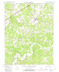
1948 Map of Leasburg
USGS Topo · Published 1980About this map
The St Louis San Francisco railroad corridor defines the development of this Crawford County landscape, connecting the settlements of Leasburg, Hofflins, and Coffeyton during the mid-20th century. While the iron horse drove early commerce, the natural topography is shaped by the winding Meramec River and the Little Bourbeuse River, which carve through the southern reaches of the quadrangle near the Mark Twain National Forest. Local history is anchored by several rural landmarks, including Mt Olive Ch and Lick Creek Ch, alongside family burial sites such as Haack Cem and Mc Nickle Cem. The presence of a Lookout Tower near Leasburg and various springs like McKee Spring and Saranac Spring illustrate a landscape transitioning from a rail-dependent rural economy to one increasingly integrated with managed forest lands and recreational water access.
Find a feature on this map
23 named features on this map. Tap any name to fly to it.
Don’t see what you’re looking for? This feature index may not catch every label — zoom into the map to look around manually.
Map Details
Editions of this 1948 Leasburg Map
5 editions found
Other maps of this area

1903 · Sullivan
USGS Topo · 1:125,000

1932 · Steelville
USGS Topo · 1:48,000

1933 · Steelville
USGS Topo · 1:62,500

1937 · Steelville
USGS Topo · 1:62,500

1943 · Berryman
USGS Topo · 1:62,500

1945 · Berryman
USGS Topo · 1:62,500

1947 · Sullivan
USGS Topo · 1:62,500

1948 · Cuba
USGS Topo · 1:24,000

1948 · Leasburg
USGS Topo · 1:24,000

1948 · Argo
USGS Topo · 1:24,000