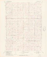
1968 Map of Lebanon
USGS Topo · Published 1971About this map
The small settlement of Lebanon serves as the focal point for this late-1960s survey of Northwest Iowa. Located in Sioux County, the area is characterized by the organized township grids of Garfield, Plato, Eagle, and Center. The map details a largely rural landscape where the social and civic life of the farming community is anchored by landmarks such as Peace Ch and the local Townhall. Water drainage is defined by the winding paths of Sixmile Creek and Dry Creek, which carve through the agricultural sections. For those researching family history in the region, the location of Highland Cem and scattered infrastructure like the Substation provide precise geographical markers of the township's development during the Missouri River Basin project era.
Find a feature on this map
11 named features on this map. Tap any name to fly to it.
Don’t see what you’re looking for? This feature index may not catch every label — zoom into the map to look around manually.
Map Details
Editions of this 1968 Lebanon Map
2 editions found

Other maps of this area

1955 · Sioux City
USGS Topo · 1:250,000

1955 · Sioux Falls
USGS Topo · 1:250,000

1958 · Sioux City
USGS Topo · 1:250,000

1958 · Sioux Falls
USGS Topo · 1:250,000

1959 · Sioux City
USGS Topo · 1:250,000

1962 · Le Mars
USGS Topo · 1:62,500

1964 · Sioux Center
USGS Topo · 1:24,000

1964 · Hull
USGS Topo · 1:24,000
1968 · Hawarden North
USGS Topo · 1:24,000

1968 · Fairview
USGS Topo · 1:24,000