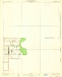
1935 Map of Lebanon
USGS Topo · Published 1935About this map
Scott Field dominates this 1930s landscape in Shiloh Valley, reflecting its significance as a military installation during the interwar years. This aviation-focused site features specific infrastructure labels including a Hangar and a Mooring Mast, indicating its role in lighter-than-air flight. To the east, the terrain transitions into the wooded bottomlands along Silver Creek. Rural life persists around the airfield, anchored by the settlement of Grassland and educational landmarks like Cherry Grove Sch and Grassland Sch. Transportation is defined by the Southern railroad line and local routes such as State Hy No 161. This survey provides a precise look at the airfield's footprint and its relationship with the surrounding agrarian community just before the expansion of World War II.
Find a feature on this map
14 named features on this map. Tap any name to fly to it.
Don’t see what you’re looking for? This feature index may not catch every label — zoom into the map to look around manually.
Map Details
Editions of this 1935 Lebanon Map
2 editions found
Other maps of this area

1906 · Breese
USGS Topo · 1:62,500

1907 · Breese
USGS Topo · 1:62,500

1907 · Belleville
USGS Topo · 1:62,500

1910 · Okawville
USGS Topo · 1:62,500

1912 · New Athens
USGS Topo · 1:62,500

1935 · Lebanon
USGS Topo · 1:24,000

1937 · Collinsville
USGS Topo · 1:24,000

1937 · O'Fallon
USGS Topo · 1:24,000

1940 · Okawville
USGS Topo · 1:62,500

1949 · Lebanon
USGS Topo · 1:24,000