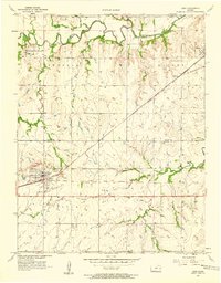
1957 Map of Lebo
USGS Topo · Published 1958About this map
The Atchison Topeka and Santa Fe railroad cuts a diagonal path through the prairie landscape, serving as the primary economic artery for the town of Lebo. This mid-century survey reveals a transition from the agricultural bottomlands of the Marais des Cygnes River in the north to the more structured grid of townships and range lines in the south. The presence of the Indian Boundary crossing through the center of the sheet provides a tangible link to 19th-century land cessions and historical geography. Smaller settlements and rural hubs like Arvonia, Olivet, and Ridgeton are documented alongside community markers including Lincoln Cem and Key West Cem. Notable localized landmarks such as a Scout Camp and the small City Park in Lebo illustrate the recreational and social focal points for residents of Osage and Coffey counties during this era.
Find a feature on this map
20 named features on this map. Tap any name to fly to it.
Don’t see what you’re looking for? This feature index may not catch every label — zoom into the map to look around manually.
Map Details
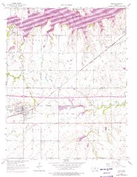
Editions of this 1957 Lebo Map
2 editions found
Other maps of this area

1885 · Burlington
USGS Topo · 1:125,000

1889 · Burlingame
USGS Topo · 1:125,000

1894 · Burlingame
USGS Topo · 1:125,000

1894 · Burlington
USGS Topo · 1:125,000

1947 · Lawrence
USGS Topo · 1:250,000

1950 · Lawrence
USGS Topo · 1:250,000

1956 · Lawrence
USGS Topo · 1:250,000
1957 · Waverly NW
USGS Topo · 1:24,000
1957 · Lebo NW
USGS Topo · 1:24,000

1961 · Lawrence
USGS Topo · 1:250,000