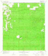
1954 Map of Lecanto
USGS Topo · Published 1966About this map
The settlement of Lecanto serves as the focal point of this mid-1950s survey of Citrus County, where the landscape is defined by its karst topography and industrial activity. Deep sinks and seasonal water bodies like Bull Sink and Fivemile Pond are scattered across the terrain, reflecting the unique hydrology of the Florida ridge. The local economy is visibly tied to the land, evidenced by the Holder Mine in the east and a Quarry near the northern boundary. Transportation infrastructure is anchored by the Seaboard Air Line railroad, which cuts through the southeastern corner near Landrum. This area demonstrates the early stages of mid-century development in the Florida interior, where small rural outposts were connected by a network of unimproved roads and critical rail corridors, punctuated by isolated features like a lone Windmill and various surveyor benchmarks.
Find a feature on this map
25 named features on this map. Tap any name to fly to it.
Don’t see what you’re looking for? This feature index may not catch every label — zoom into the map to look around manually.
Map Details
Editions of this 1954 Lecanto Map
5 editions found
Other maps of this area

1895 · Tsala Apopka
USGS Topo · 1:62,500

1954 · Lecanto
USGS Topo · 1:24,000

1954 · Homosassa
USGS Topo · 1:24,000

1954 · Holder
USGS Topo · 1:24,000

1954 · Crystal River
USGS Topo · 1:24,000

1954 · Brooksville NW
USGS Topo · 1:24,000

1954 · Nobleton
USGS Topo · 1:24,000

1954 · Tsala Apopka NE
USGS Topo · 1:24,000

1954 · Chassahowitzka
USGS Topo · 1:24,000

1954 · Inverness
USGS Topo · 1:24,000