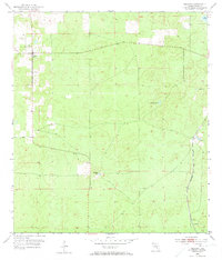
1954 Map of Lecanto
USGS Topo · Published 1973About this map
The settlement of Lecanto serves as a focal point for this mid-century Florida interior, where small rural communities were interconnected by early secondary roads and industrial rail. To the southeast, Landrum sits near the tracks of the Seaboard Air Line, which facilitated the transport of local materials from sites such as the Holder Mine and a local Quarry. The landscape is defined by its karst topography, characterized by numerous depressions and water bodies including Bull Sink, Fivemile Pond, Hog Pond, and Mansfield Pond. These features illustrate the natural hydrology and drainage patterns of the area before the onset of significant modern development, providing a clear record of the relationship between industrial extractive sites and the local terrain.
Find a feature on this map
11 named features on this map. Tap any name to fly to it.
Don’t see what you’re looking for? This feature index may not catch every label — zoom into the map to look around manually.
Map Details
Editions of this 1954 Lecanto Map
5 editions found
Other maps of this area

1895 · Tsala Apopka
USGS Topo · 1:62,500

1954 · Lecanto
USGS Topo · 1:24,000

1954 · Homosassa
USGS Topo · 1:24,000

1954 · Holder
USGS Topo · 1:24,000

1954 · Crystal River
USGS Topo · 1:24,000

1954 · Brooksville NW
USGS Topo · 1:24,000

1954 · Nobleton
USGS Topo · 1:24,000

1954 · Tsala Apopka NE
USGS Topo · 1:24,000

1954 · Chassahowitzka
USGS Topo · 1:24,000

1954 · Inverness
USGS Topo · 1:24,000