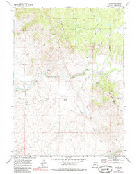
1969 Map of Leckie
USGS Topo · Published 1985About this map
Lander Cutoff of the Emigrant Trail bisects this Wyoming landscape, tracing a historic path through the high country of the Bridger National Forest. The map details the intersection of early westward migration routes and modern resource management, where the drainage of the Big Sandy River meets features like Muddy Ridge and Prospect Mountain. The settlement of Leckie sits near the river's bend, surrounded by a network of seasonal water sources and livestock-oriented improvements such as Tally Pit Reservoir and Blue Pit Reservoir. A lonely grave marked on the northern slopes above Sandy Creek serves as a silent reminder of the hardships faced by travelers on the historic trails that once served as the primary arteries for those heading toward the Pacific.
Find a feature on this map
23 named features on this map. Tap any name to fly to it.
Don’t see what you’re looking for? This feature index may not catch every label — zoom into the map to look around manually.
Map Details
Editions of this 1969 Leckie Map
3 editions found
Other maps of this area

1955 · Lander
USGS Topo · 1:250,000

1958 · Lander
USGS Topo · 1:250,000

1958 · Parting of the Ways
USGS Topo · 1:62,500

1961 · Lander
USGS Topo · 1:250,000

1969 · Pocket Creek Lake
USGS Topo · 1:24,000

1969 · Leckie Reservoir
USGS Topo · 1:24,000

1969 · Leckie SW
USGS Topo · 1:24,000

1969 · Jensen Meadows
USGS Topo · 1:24,000

1969 · Tabernacle Butte
USGS Topo · 1:24,000
1969 · Big Sandy Opening
USGS Topo · 1:24,000