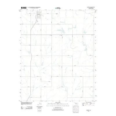
2012 Map of Leedey
USGS Topo · Published 2012About this map
Leedey stands as the primary hub in this portion of Dewey County, where the street grid transitions into a vast network of section-line roads. The landscape is defined by the headwaters and tributaries of several drainage systems, including the N Br Quartermaster Cr to the west and Wild Horse Cr to the south. Water management is a central theme of the local geography, evidenced by a series of numbered catchment areas such as Barnitz Cr Site 1a Reservoir and Barnitz Cr Site 3 Reservoir, alongside recreation spots like Leedey Lake. For those researching local genealogy, the map identifies several burial sites situated along the rural township roads, notably Evergreen Cem, New Herman Cem, and Rhea Cem on the eastern edge. This 2012 survey illustrates the persistent agricultural and water-conservation patterns of western Oklahoma.
Find a feature on this map
30 named features on this map. Tap any name to fly to it.
Don’t see what you’re looking for? This feature index may not catch every label — zoom into the map to look around manually.
Map Details
Editions of this 2012 Leedey Map
This is the sole edition of this map. No revisions or reprints were ever made.
Other maps of this area

1955 · Clinton
USGS Topo · 1:250,000

1957 · Clinton
USGS Topo · 1:250,000

1957 · Butler
USGS Topo · 1:62,500

1960 · Hammon
USGS Topo · 1:62,500

1961 · Leedey
USGS Topo · 1:62,500

1962 · Aledo
USGS Topo · 1:62,500

1976 · Butler NW
USGS Topo · 1:24,000
1983 · Butler
USGS Topo · 1:24,000

1984 · Foss Reservoir
USGS Topo · 1:100,000
1984 · Rhea
USGS Topo · 1:24,000