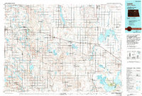
1985 Map of Leeds
USGS Topo · Published 1994About this map
Burlington Northern and Soo Line tracks crisscross this prairie landscape, defining the growth of farming communities across Benson and Ramsey counties in the mid-1980s. The region is characterized by a high concentration of protected wetlands, including the National Waterfowl Production Area and numerous state wildlife management areas that surround glacial water bodies like Lake Ibsen and the Chain Lakes. Near the southeastern corner, the map details the northern reaches of the Fort Totten Indian Reservation and the extensive shoreline of Devils Lake at West Bay. Smaller townships such as Esmond, Knox, and Minnewaukan serve as local hubs, preserved here alongside rural landmarks like the Knox Ch and several pioneer-era burial grounds including Leeds Cem. The intricate network of coulees and lakes highlights a drainage system typical of the North Dakota drift prairie before significant modern hydrological changes.
Find a feature on this map
126 named features on this map. Tap any name to fly to it.
Don’t see what you’re looking for? This feature index may not catch every label — zoom into the map to look around manually.
Map Details
Editions of this 1985 Leeds Map
This is the sole edition of this map. No revisions or reprints were ever made.
Other maps of this area

1928 · Tokio
USGS Topo · 1:62,500

1931 · Oberon
USGS Topo · 1:62,500

1931 · Tokio
USGS Topo · 1:62,500

1931 · Devils Lake
USGS Topo · 1:62,500

1932 · Flora
USGS Topo · 1:62,500

1932 · Grahams Island
USGS Topo · 1:62,500

1940 · Aylmer
USGS Topo · 1:62,500

1941 · Selz
USGS Topo · 1:62,500

1943 · Maddock
USGS Topo · 1:62,500

1945 · Maddock
USGS Topo · 1:62,500