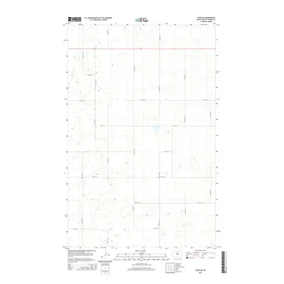
2014 Map of Leeds NE
USGS Topo · Published 2014About this map
The prairie landscape of Towner County is defined by its precise agrarian geometry in this early twenty-first-century record. Running east-west across the northern portion of the quadrangle, ND-17 provides the primary transit artery through this rural expanse. The remainder of the terrain is partitioned by a strict network of gravel and section roads, including north-south corridors like 61st Ave NE and 63rd Ave NE. This cartographic study illustrates the enduring Township and Range system, where large-scale farming operations are serviced by local routes such as 73rd St NE and 72nd St NE. The lack of named settlements reflects the low population density characteristic of the North Dakota plains, where the focus remains on the vast agricultural sections between the county roads.
Find a feature on this map
15 named features on this map. Tap any name to fly to it.
Don’t see what you’re looking for? This feature index may not catch every label — zoom into the map to look around manually.
Map Details
Editions of this 2014 Leeds NE Map
This is the sole edition of this map. No revisions or reprints were ever made.
Other maps of this area

1953 · Devils Lake
USGS Topo · 1:250,000

1956 · Devils Lake
USGS Topo · 1:250,000

1957 · Cando
USGS Topo · 1:24,000

1957 · Churchs Ferry
USGS Topo · 1:24,000

1962 · Egeland SW
USGS Topo · 1:24,000

1971 · Bisbee South
USGS Topo · 1:24,000

1971 · Considine
USGS Topo · 1:24,000

1971 · Leeds NE
USGS Topo · 1:24,000

1971 · Leeds
USGS Topo · 1:24,000
1971 · Hurricane Lake East
USGS Topo · 1:24,000