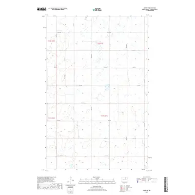
2017 Map of Leeds NE
USGS Topo · Published 2017About this map
Towner County in North Dakota is defined by its regular section lines and persistent wetlands, as seen in this 2017 survey of the plains. The landscape is organized by a precise grid of rural roads, including 74th St NE and 60th Ave NE, which provide access to the various sections across T158n R67w and T157n R67w. This map reveals a region dominated by scattered seasonal ponds and depressions, a characteristic of the Prairie Pothole Region, where drainage and land management are critical to agricultural use. While no major towns occupy this specific quadrant, the density of the section-line road network like 72nd St NE and 65th Ave NE indicates a highly utilized and surveyed farming landscape where property boundaries follow the rigid lines of the Public Land Survey System.
Find a feature on this map
19 named features on this map. Tap any name to fly to it.
Don’t see what you’re looking for? This feature index may not catch every label — zoom into the map to look around manually.
Map Details
Editions of this 2017 Leeds NE Map
This is the sole edition of this map. No revisions or reprints were ever made.
Other maps of this area

1953 · Devils Lake
USGS Topo · 1:250,000

1956 · Devils Lake
USGS Topo · 1:250,000

1957 · Cando
USGS Topo · 1:24,000

1957 · Churchs Ferry
USGS Topo · 1:24,000

1962 · Egeland SW
USGS Topo · 1:24,000

1971 · Bisbee South
USGS Topo · 1:24,000

1971 · Considine
USGS Topo · 1:24,000

1971 · Leeds NE
USGS Topo · 1:24,000

1971 · Leeds
USGS Topo · 1:24,000
1971 · Hurricane Lake East
USGS Topo · 1:24,000