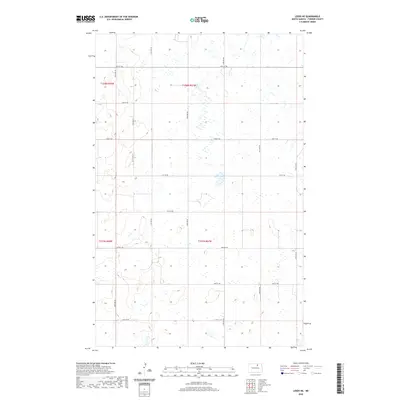
2020 Map of Leeds NE
USGS Topo · Published 2020About this map
Towner County's prairie landscape is defined by the rigid precision of the Public Land Survey System, as seen in this 2020 map of the Leeds NE area. The land is meticulously carved into sections across several townships, including t158n r68w, t158n r67w, t157n r68w, and t157n r67w. A dense network of gravel and local roads follows these section lines, creating a geometric grid of agriculture and homesteading. Notable thoroughfares like 74th St NE and 60th Ave NE bisect a terrain dotted with numerous small potholes and wetlands, characteristic of the North Dakota drift plain. This map serves as a detailed record of modern rural land use and the enduring influence of the original territorial surveys on the modern county road system.
Find a feature on this map
19 named features on this map. Tap any name to fly to it.
Don’t see what you’re looking for? This feature index may not catch every label — zoom into the map to look around manually.
Map Details
Editions of this 2020 Leeds NE Map
This is the sole edition of this map. No revisions or reprints were ever made.
Other maps of this area

1953 · Devils Lake
USGS Topo · 1:250,000

1956 · Devils Lake
USGS Topo · 1:250,000

1957 · Cando
USGS Topo · 1:24,000

1957 · Churchs Ferry
USGS Topo · 1:24,000

1962 · Egeland SW
USGS Topo · 1:24,000

1971 · Bisbee South
USGS Topo · 1:24,000

1971 · Considine
USGS Topo · 1:24,000

1971 · Leeds NE
USGS Topo · 1:24,000

1971 · Leeds
USGS Topo · 1:24,000
1971 · Hurricane Lake East
USGS Topo · 1:24,000