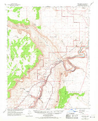
1954 Map of Lees Ferry
USGS Topo · Published 1971About this map
The confluence of the Colorado River and the Paria River serves as the focal point of this mid-century survey, conducted just as the region prepared for significant infrastructure shifts. This area, dominated by the towering Vermilion Cliffs and the deep incisions of Glen Canyon, features the historic Lees Ferry and its associated Gaging Sta, long the critical crossing point for travelers between Arizona and Utah. The map documents the landscape prior to the completion of the Glen Canyon Dam, showing the river corridor as it existed with a Cableway and the landmark Navajo Bridge providing the only high-road transit across the chasm.
Find a feature on this map
51 named features on this map. Tap any name to fly to it.
Don’t see what you’re looking for? This feature index may not catch every label — zoom into the map to look around manually.
Map Details
Editions of this 1954 Lees Ferry Map
4 editions found

Other maps of this area

1886 · Escalante
USGS Topo · 1:250,000

1886 · Echo Cliffs
USGS Topo · 1:250,000

1891 · Echo Cliffs
USGS Topo · 1:250,000

1922 · Warm Creek
USGS Topo · 1:63,360

1951 · Lees Ferry NE
USGS Topo · 1:24,000

1953 · Nipple Butte
USGS Topo · 1:62,500

1953 · Gunsight Butte
USGS Topo · 1:62,500

1954 · Lees Ferry NW
USGS Topo · 1:24,000

1954 · Emmett Wash NE
USGS Topo · 1:24,000

1954 · Paria Plateau SE
USGS Topo · 1:24,000