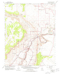
1954 Map of Lees Ferry
USGS Topo · Published 1978About this map
Colorado River navigation and the crossing at Lees Ferry anchor this mid-century survey of Northern Arizona. This map, developed in cooperation with the Atomic Energy Commission, documents the dramatic geography where the Vermilion Cliffs and Marble Canyon converge. The landscape is defined by its verticality, from Cedar Mountain to the depths of Paria Canyon. Small outposts like Vermilion Cliffs Lodge and the Lees settlement represent the sparse human presence in this region. The map also records early engineering feats, notably the Navajo Bridge spanning the gorge and the survey of the Glen Canyon National Recreation Area boundaries before extensive modern development. Features such as Powells Monument and Cathedral Rock serve as significant landmarks for those tracing the history of river exploration and plateau transit.
Find a feature on this map
41 named features on this map. Tap any name to fly to it.
Don’t see what you’re looking for? This feature index may not catch every label — zoom into the map to look around manually.
Map Details
Editions of this 1954 Lees Ferry Map
4 editions found

Other maps of this area

1886 · Escalante
USGS Topo · 1:250,000

1886 · Echo Cliffs
USGS Topo · 1:250,000

1891 · Echo Cliffs
USGS Topo · 1:250,000

1922 · Warm Creek
USGS Topo · 1:63,360

1951 · Lees Ferry NE
USGS Topo · 1:24,000

1953 · Nipple Butte
USGS Topo · 1:62,500

1953 · Gunsight Butte
USGS Topo · 1:62,500

1954 · Lees Ferry NW
USGS Topo · 1:24,000

1954 · Emmett Wash NE
USGS Topo · 1:24,000

1954 · Paria Plateau SE
USGS Topo · 1:24,000