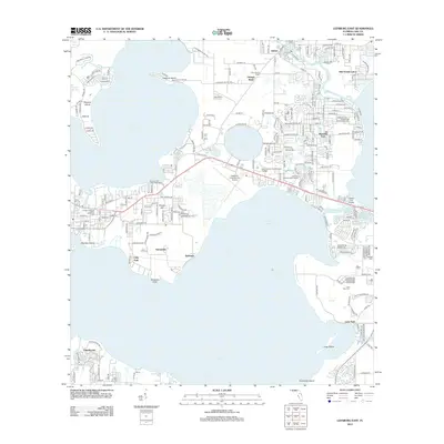
2012 Map of Leesburg East
USGS Topo · Published 2012About this map
Lake Harris and Lake Griffin dominate this central Florida landscape, connected by the narrow corridor of the Dead River. This 2012 survey illustrates the residential and commercial density surrounding Leesburg International Airport and Lake Sumter Community College. Smaller residential enclaves like Bassville Park and Mid Florida Lakes are situated among numerous smaller water bodies including Silver Lake and Lake Eustis. The map records significant industrial footprints such as the Cutrale Company Water Tower alongside local landmarks like the Leesburg Lakefront Water Tower and Al Jana Fish Camp Boat Ramp. Local history and genealogy interest is found in the locations of Tavares Cem and Lane Park Cem, as well as named points like Johnsons Point and islands such as Monkey Island and Treasure Island.
Find a feature on this map
212 named features on this map. Tap any name to fly to it.
Don’t see what you’re looking for? This feature index may not catch every label — zoom into the map to look around manually.
Map Details
Editions of this 2012 Leesburg East Map
This is the sole edition of this map. No revisions or reprints were ever made.
Other maps of this area

1955 · Orlando
USGS Topo · 1:250,000

1957 · Orlando
USGS Topo · 1:250,000

1958 · Orlando
USGS Topo · 1:250,000

1962 · Orlando
USGS Topo · 1:250,000

1962 · Astatula
USGS Topo · 1:24,000

1965 · Leesburg East
USGS Topo · 1:24,000

1965 · Umatilla
USGS Topo · 1:24,000

1966 · Leesburg West
USGS Topo · 1:24,000
1966 · Lady Lake
USGS Topo · 1:24,000
1966 · Eustis
USGS Topo · 1:24,000