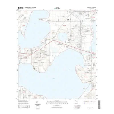
2015 Map of Leesburg East
USGS Topo · Published 2015About this map
Leesburg and Tavares anchor this survey of Central Florida's lake-interspersed landscape, where the water is as much a part of the layout as the residential developments. The area is defined by the massive expanses of Lake Griffin to the northwest and Lake Harris to the south, connected by the narrow channel of the Dead River. This hydrographic network historically dictated settlement patterns, visible in the way communities like Sunnyside and Eldorado follow the high ground between the basins. The map captures the infrastructure supporting this region, from the Leesburg International Airport to the Lake-Sumter Community College campus. Notable landmarks like Tomato Hill and Monkey Island punctuate the terrain, while the Slater Cox Bridge provides a critical crossing over the marshes. The inclusion of Lane Park Cemetery and smaller hamlets such as Lisbon provides essential detail for local history and genealogical research.
Find a feature on this map
46 named features on this map. Tap any name to fly to it.
Don’t see what you’re looking for? This feature index may not catch every label — zoom into the map to look around manually.
Map Details
Editions of this 2015 Leesburg East Map
This is the sole edition of this map. No revisions or reprints were ever made.
Other maps of this area

1955 · Orlando
USGS Topo · 1:250,000

1957 · Orlando
USGS Topo · 1:250,000

1958 · Orlando
USGS Topo · 1:250,000

1962 · Orlando
USGS Topo · 1:250,000

1962 · Astatula
USGS Topo · 1:24,000

1965 · Leesburg East
USGS Topo · 1:24,000

1965 · Umatilla
USGS Topo · 1:24,000

1966 · Leesburg West
USGS Topo · 1:24,000
1966 · Lady Lake
USGS Topo · 1:24,000
1966 · Eustis
USGS Topo · 1:24,000