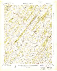
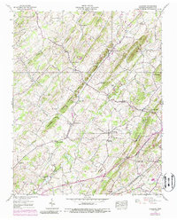
1939 Map of Leesburg
USGS Topo · Published 1939About this map
Leesburg and the surrounding Washington County landscape are defined by a network of rural schoolhouses and country churches that anchored community life just before World War II. The terrain is structured by prominent ridges like Mitchell Ridge and Chestnut Ridge, which funnel the local drainage into the Muddy Fork and Limestone Creek. Small agrarian settlements such as Bowmantown and Hartmantown are connected by a web of early highways and the Southern railroad line at the southern edge of the sheet near Telford. The presence of specialized landmarks like the Keebler Institute and the Union Tabernacle suggests a culturally active region, while legacy sites like Taylor Mill and Keys Mill along the watercourses reflect a long-standing milling economy. This survey captures the transition of the Tennessee Valley as traditional agricultural centers began to integrate more closely with regional transportation corridors.
Find a feature on this map
65 named features on this map. Tap any name to fly to it.
Don’t see what you’re looking for? This feature index may not catch every label — zoom into the map to look around manually.
Map Details
Editions of this 1939 Leesburg Map
5 editions found
Other maps of this area

1891 · Roan Mountain
USGS Topo · 1:125,000

1892 · Greeneville
USGS Topo · 1:125,000

1894 · Roan Mountain
USGS Topo · 1:125,000

1896 · Greeneville
USGS Topo · 1:125,000

1904 · Roan Mountain
USGS Topo · 1:125,000

1904 · Greeneville
USGS Topo · 1:125,000

1935 · Lovelace
USGS Topo · 1:24,000

1935 · Sullivan Gardens
USGS Topo · 1:24,000

1935 · Leesburg
USGS Topo · 1:24,000

1935 · Erwin
USGS Topo · 1:24,000